
This trip will take you to witness the breathtaking autumn foliage at Kamikochi, Japan. The itinerary focuses on easy hiking trails suitable for beginners, eliminating the need for advanced climbing or rock climbing skills. Nevertheless, the scenery at Kamikochi is guaranteed to be "spectacular." If you're ready, let's embark on this journey to Kamikochi together.

**
** **
1. Regarding Kamikochi
Kamikochi: A Natural Paradise in the Japanese Alps
Kamikochi, a national park in the western region of Nagano Prefecture, is nestled amidst the renowned Japan Alps. This scenic plateau stretches for approximately 15 kilometers along the Azusa River, offering a breathtaking natural escape.
Located at an average elevation of 1,500 meters above sea level and surrounded by towering peaks of the Japan Alps, Kamikochi experiences consistently low temperatures throughout the year. This, coupled with its breathtaking scenery, makes Kamikochi a highly popular natural tourist destination.
Kamikochi is only open to visitors from mid-April to mid-November each year. It is closed during the winter season. You can check the opening calendar for each year on the park's website at http://www.kamikochi.org/.

Advertisement

Phase 1: Tokyo - Matsumoto
Our journey began in Tokyo, as planned. In addition to visiting Kamikochi, we also made stops in the city of Matsumoto and the Norikura高原. (We purchased a 2-day free passport from Alpico for 6,000 yen to use for travel between Matsumoto, Kamikochi, and Norikura.)
Therefore, we set off from Tokyo and established our base in Matsumoto City first (in fact, Kamikochi can be accessed from both Matsumoto City and Takayama City).
If you know your return date, it is recommended to purchase both your departure and return tickets together when booking. This will often result in a discount. While there are multiple departures daily, booking in advance is still advisable, as popular time slots can fill up quickly. Even with departures every day, we found that our preferred time slot was nearly full when we booked just 2-3 days in advance.
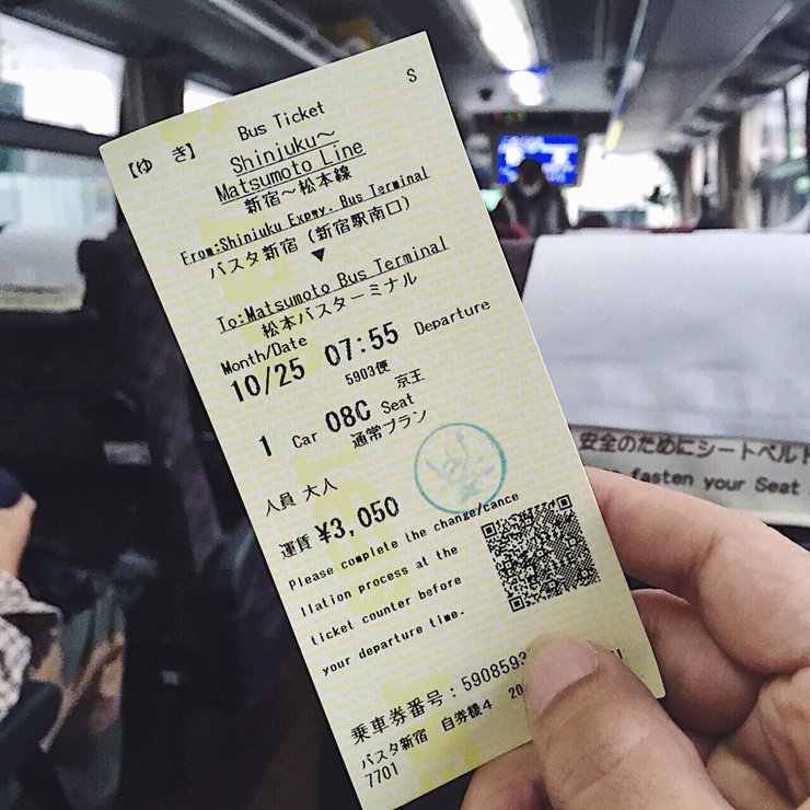
We opted for the bus service instead of the train because we did not purchase a JR pass. Purchasing a round-trip train ticket from Tokyo to Matsumoto would have cost approximately 14,000 yen, whereas the bus journey was significantly more affordable. While the bus journey takes approximately 3 hours and 30 minutes, which is slightly longer than the train journey of around 2 hours and 45 minutes, the cost savings made the bus a more attractive option.
In terms of travel time, the train might be slightly faster, but not significantly so. However, considering the cost of tickets, the bus is a more economical option. A round-trip bus ticket costs 7,000 yen, while a round-trip train ticket costs 14,000 yen. Therefore, the choice is clear: the bus is the more cost-effective option.
Taking the bus is significantly more economical and eliminates the need to repeatedly load and unload luggage onto and off trains (as multiple transfers are required on cheaper train options). With the bus, you can simply store your luggage under the vehicle and enjoy a direct journey from Tokyo to Matsumoto.
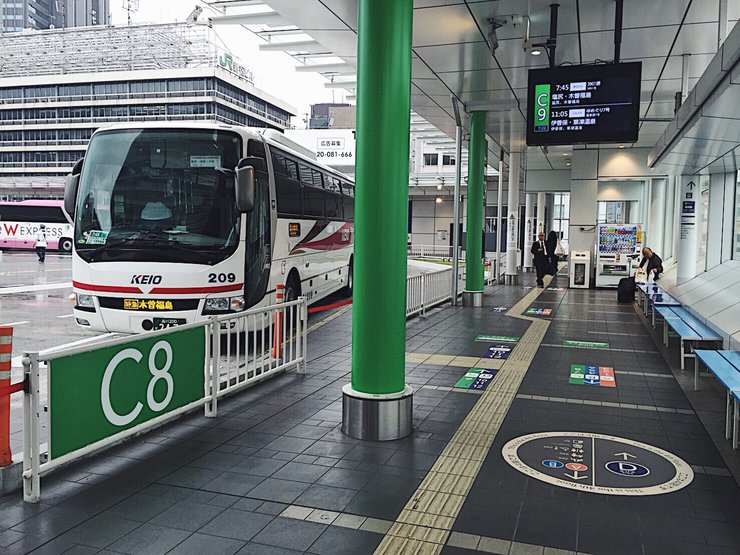
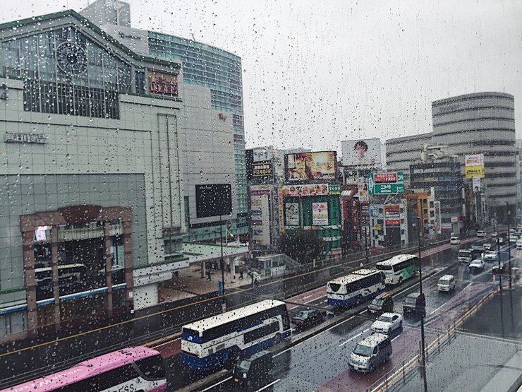
- The bus station at Shinjuku is easy to find, located in the same building as the JR train station. However, the bus station is on the upper floor. -

- A photo taken from the top of a bus station in Shinjuku during a trip to Tokyo, where it rained the entire time. -

Advertisement
** **
- The bus fare from Tokyo to Matsumoto is approximately 3,000 to 3,500 yen one way. -

****
After a three-hour car ride, we arrived in Matsumoto. We had booked a room at the M Hotel Matsumoto, a newly opened hotel with affordable prices and a variety of room options, including single rooms and shared rooms.
We opted for a capsule dormitory room, which cost around 600 baht per night. Choosing this hotel was a wise decision due to its excellent location. It is situated right next to the bus and train stations. Additionally, there are numerous mini-marts conveniently located in front of the hotel. Overall, it was an incredibly convenient experience. (The bus and train stations in Matsumoto are located directly opposite each other, separated only by a road.)
- According to Google Maps, the hotel, bus station, and train station are all in close proximity. -

- The atmosphere at the counter of the M Hotel Matsumoto -

There is a bus service available for those who do not have plans to visit other places and want to travel directly from Tokyo to Kamikochi. Buses depart from Shinjuku Station in the morning and evening. After your trip, you can take a bus back from Kamikochi around 3:00 PM - 4:00 PM, arriving back in Tokyo around 9:00 PM. The round-trip bus fare is approximately 15,000 yen.
While traveling directly to Kamikochi is an option, we recommend considering a stopover in Matsumoto. The cost difference between a direct bus and an overnight stay in Matsumoto, including a ticket from Matsumoto to Kamikochi, is minimal. This approach allows for a more enjoyable and fulfilling travel experience, providing ample time to explore Matsumoto's attractions.
Part Two: Matsumoto - Kamikochi
We purchased a 2-day free passport ticket for 6,000 yen from Alpico to travel between Matsumoto and Kamikochi and Norikura on separate days. (I will review Norikura later.)
Traveling from Matsumoto to Kamikochi is straightforward. Buses depart from Matsumoto Station, with two direct services daily at 5:30 AM and 10:15 AM.
However, if you are unable to make either of these trips, there are numerous other options available, including bus or train departures from Matsumoto to Kamikochi. If you choose to travel on a different schedule, whether by bus or train, you will need to transfer to another bus at Shinshimashima Station before continuing to Kamikochi. (However, the travel time is not significantly different between direct and connecting services.)
You can check the bus schedule update time for each period on the website of Alpico, the company that operates buses from Matsumoto to Kamikochi. The website also provides information in Thai.
http://www.alpico.co.jp/th/transportation/detail.php?id=20
- Example of a morning bus schedule from Matsumoto to Kamikochi -

- Sample afternoon bus schedule from Kamikochi to Matsumoto -
Advertisement

 Check Hotel Deals in nagano


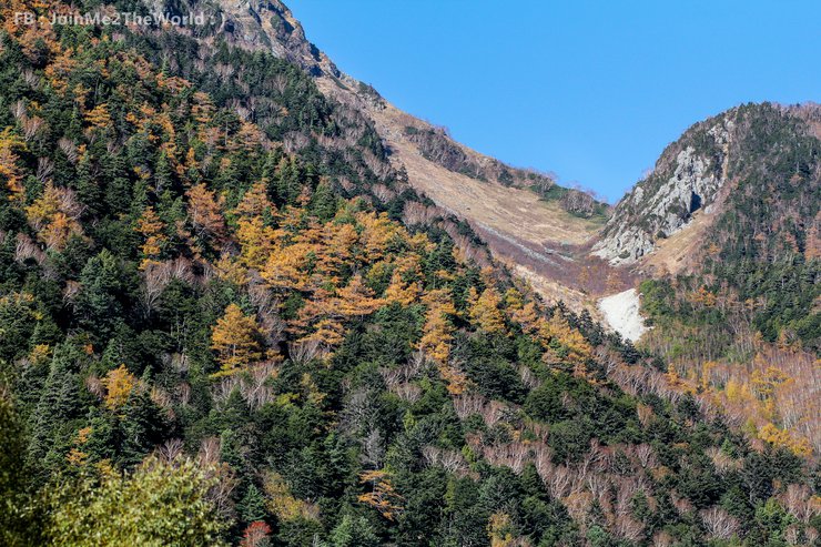
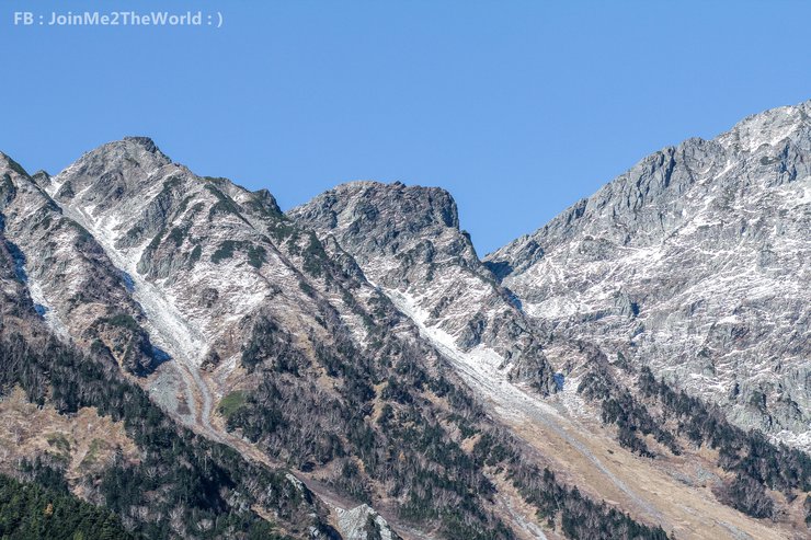
The weather in Kamikochi is characterized by low average temperatures and a cool climate throughout the year. During our visit in mid-October, which coincided with the fall foliage season, the morning air was particularly cold. Exiting the bus, our breath formed visible white clouds, indicating a temperature likely in the single digits. Prior to leaving Matsumoto City, the temperature was recorded at 10 degrees Celsius. Given Kamikochi's higher altitude, the temperature was expected to be even lower.
In the morning, it was necessary to wear a down jacket and gloves to stay warm, as the temperature was cold enough to cause numbness in the hands. However, as the sun came out in the late morning and we began to walk around, we started to sweat. We removed the down jacket and stored it in our backpacks, leaving only a long-sleeved shirt. The temperature was pleasant, neither too cold nor too hot, and we were able to walk comfortably. The temperature in the late morning was estimated to be between 15 and 20 degrees Celsius.
- The morning before the sun rises, the weather is quite cold. You need to wear a down jacket to stay warm. -

- The majority of the trail around the park follows the Azusa River. -

- The main path is flat and easy to walk on... even elderly people can walk comfortably. -

- I noticed many elderly people in Japan traveling alone. -

** **
Along the trail, you will encounter signs from the park warning you to be aware of bears. Some Japanese tourists hang bells on their backpacks to make a jingling sound as they walk, alerting bears to their presence and preventing them from surprising tourists. However, it is still important to be vigilant and look around, especially when walking near pine forests.

3. What are the attractions and photo opportunities in Kamikochi?

Estimated Walking Times for Tourist Spots in Kamikochi

**
The journey took place in mid-October, coinciding with the fall foliage season. Eager to capture the morning scenery at Taisho Pond, we opted for an early bus departing Matsumoto at 5:30 AM. The 1.5-hour ride brought us to Kamikochi by 7:00 AM. While the early wake-up call demanded some sacrifice, the breathtaking views upon arrival undoubtedly justified the effort.
Note: The original text's informal tone and personal pronouns have been replaced with a more formal academic style. The translation avoids colloquialisms and focuses on conveying the essential information in a concise and objective manner.

** **

** **
**When taking the bus to Kamikochi, the driver will stop at the first stop, Taisho Pond. If you want to take photos here, you can get off at this stop. If you don't get off at this stop, the bus will take you to the final stop at Kamikochi Bus Terminal, and you will have to walk back. Don't worry about getting confused and not knowing which stop is Taisho Pond. Just look for the stop where a lot of photographers are getting off the bus. That's it!**
At dawn, photographers gather at Taisho Pond in Kamikochi to capture the breathtaking reflection of the mountains in the water. The pond's unique property allows it to reflect everything, from the sky and mountains to the trees and even the photographers themselves. On a clear day with calm water, prepare to be mesmerized by the stunning reflections and capture countless photographs.
- A popular photo spot at Taisho Pond... If you don't take a picture here, you haven't really been here, haha! -

- I must say, I'm truly impressed by the water reflections here... Even the photographer's shadow is reflected. Take a look for yourself. -

- This is the actual reflection of the water, not added in Photoshop. -

**

** **

** **

** **


From Taisho Pond, after taking photos for a while, we started walking to the next point. Along the way, there was an open forest with a wooden bridge path that stretched along the swamp or shallow pond in the open forest. … After walking a short distance, we reached the Yakedake Mountain summit viewpoint, which is an active volcano.
- Yakedake Mountain Summit Viewpoint -

** **


** **
From the Hotaka Mountain Range viewpoint, there is a fork in the road. If we turn right and continue walking, the next point we will reach is Tashiro Pond. The water level in this pond is shallower than Lake Taisho, and the water in this pond comes from underground seepage, making it cool to the touch all year round, even in the hot summer months.
- Viewpoint at Tashiro Pond -

**Please provide the text you would like me to translate.**

**
**

**Please provide the text you would like me to translate.**

** **

After visiting Lake Tashiro Poud, we walked back to the main road where the Mount Hotaka viewpoint is located. At the intersection, we turned left and continued walking. After passing through the pine forest, we walked along the Asuza River.

Upon reaching Tashiro Bridge, you will have the option to choose which side of the Asuza River you would like to follow. Both paths run parallel to each other, with the river separating them. To cross to the other side, you will need to continue walking until you reach Kappa Bridge.
- Scenic Viewpoint at Tashiro Bridge -


** **
Indecisive about which side to walk from, we had ample time, so we opted to loop around twice, taking in the sights from both the left and right banks. Haha! As for which side boasts the better view, it's impossible to say – both are truly stunning. If you're feeling energetic and have time to spare, follow our lead and walk a full circle (one loop from Tashiro Bridge to Kappa Bridge and back).
If you prefer to explore only one side of the river, we recommend walking from Tashiro Bridge to Kappa Bridge along the right bank. This is because you will encounter the bus stop before reaching Kappa Bridge, allowing you to inquire about return bus schedules. (If you have time and energy after reaching Kappa Bridge, you can always return and explore the other side.)
After choosing a side, continue on the Asuza River Trail, which runs through the heart of Kamikochi. The Asuza River's water is incredibly clear and green, and when it reflects the sunlight, it sparkles. There are many beautiful photo opportunities along the trail on both sides of the river. The view from the large bend in the river near the hotel is particularly spectacular, like being in paradise.
- Another favorite spot in Kamikochi is the large bend in the Asuza River. -


** **

**

** **

** **

** **
- Asuza River Trail on the right bank of the river -


****

Tourists can be seen picnicking and enjoying packed lunches with stunning natural views. A midday meal at Kamikochi is an unforgettable experience.

** **

The sentence is already in English and does not require translation.

** **


**
**


** **
Officers will provide queue tickets for that round. After receiving the ticket, you can continue exploring the area. ... After exploring the area, when the bus is about to depart, please wait at this location to board the bus. When the bus arrives, officers will call passengers to board according to their queue numbers. Passengers with earlier queue numbers will board the bus first, as announced in the previous round. However, if you have a later queue number and the bus is full, you will need to wait for the next bus.
Therefore, it is recommended to contact the bus terminal to inquire about the return trip schedule first. Once you have secured your return bus ticket, you can then explore other attractions. (If you are walking from the left bank of the river, you need to cross the bridge at Kappa Bridge and walk back down a bit to find the bus stop.)
- Kamikochi Bus Terminal is a bus stop with truly breathtaking views.

**I am ready to translate your sentences from Thai to English.**


**
**

** **


** **

** **

Similarly, looking back from the Kappa Bridge, the view is equally breathtaking. It showcases the majestic Yakedake Mountain and the serene Asuza River, which we followed along the nature trail.

The area around Kappa Bridge is home to a tourist information center, hotels, restaurants, cafes, and souvenir shops, catering to the needs of visitors. This area tends to be more crowded due to its popularity.

Tourists can choose to stay in hotels, which are a bit expensive, or if they are backpackers, they can choose to camp and enjoy the natural scenery. I am not sure about the fee, but if anyone is interested, they should contact the park directly for more information.

** **

Roughly calculated, it takes about 2 hours to walk back and forth. If we want to continue, we should allow enough time to catch the bus back. Otherwise, we might miss the bus and have to work overtime.
We will start by walking along the right bank until we reach Myojin Bridge. We will then cross back to the left bank to visit Myojin Pond (located near Myojin Bridge). Finally, we will walk back from the left bank to Kappa Bridge.
Continuing the walk by turning right from Kappa Bridge, you will soon see the accommodation zone and camping area within the park.

** **
"Continuing on, you will encounter the riverside accommodation zone within the park. The atmosphere is incredibly inviting and perfect for a relaxing stay."


** **

**I am ready to translate sentences from Thai to English. Please provide the sentences you would like me to translate.**

** **

**
**
Finally, we arrived at the Myojin Bridge. Even though I exercised frequently back in Thailand, the long walk and heavy camera bag started to take their toll on my legs. I was exhausted! Haha.
It is worth noting that elderly people in Japan are remarkably adept at walking. For instance, we observed an elderly couple, both the grandfather and grandmother, walking slowly and steadily, supporting each other along the way.

** **

- Photo of the scenic view from Myojin Bridge.


****
- A scenic view of Myojin Pond with colorful autumn leaves reflected in the water.

** **


**
**

**Please provide the text you would like me to translate.**

** **

While Myojin Pond marks the end of the beginner-friendly trail, the adventure continues for those seeking a more challenging experience. The advanced route requires several hours of strenuous trekking across flat terrain, followed by a steep ascent up the mountain. Despite the frigid temperatures at the summit, the breathtaking views during the fall foliage season are unparalleled, consistently ranking among the most stunning in all of Japan.
This time, I couldn't take it anymore. Just walking to Myojin Pond made my legs drag. Haha. When I came out of Myojin Pond, I walked back to the bus stop, and I had to hurry because I was afraid of missing the bus to Matsumoto. My legs were starting to wobble. I took very few pictures on the way back.
Note: The original text is in Thai, and the translation is in English.


** **
Upon reaching Kappa Bridge, I must admit that I was completely exhausted. I had walked a significant distance that day, approximately 13 kilometers, and my energy was depleted.


After recharging at the rest stop, walk back to the bus station and present your ticket for the time slot you booked (it's recommended to arrive before the bus departure time). The staff will arrange for you to board the bus according to the queue. However, some buses may be overbooked. If you haven't booked a ticket and the bus is full, you will have to wait for the next available bus.

The day we visited Kamikochi was a stroke of luck. Throughout our 10-day trip to Japan, we had encountered rain and storms for 7 days. However, the day we arrived at Kamikochi, the sun was shining brightly.
- This concludes our photo series of Kamikochi -

- Here's a picture of the fall foliage at Norikura as a small deposit. Haha! -


------------------------------------------------------------------------------------------------
If you have any questions or want to discuss further, please feel free to contact us: )
FB: https://www.facebook.com/JoinMe2TheWorld
------------------------------------------------------------------------------------------------


JoinMe2TheWorld : )
Wednesday, February 26, 2025 7:06 PM